
BASICS
What is a watershed?
 A watershed is the land area that drains to a common outlet like a stream, lake or river and affects the water quality in the water body that it surrounds. A ridge that separates two watersheds is called the drainage divide. We all live in a watershed, and watershed condition is important to everyone and everything that uses and needs water (USEPA 2017).
Watersheds are geographically nested, and in the HUC (hydrologic unit code) classification range from 2 to 16 digits. HUCs also have descriptive names, which are useful for understanding different scales of watershed management.
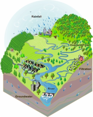
In a watershed, stormwater flows overland and enters the nearest waterbody. Source: Arkansas Watershed Advisory Groups
USGS HUCs and descriptive names according to watershed scale.
| HUC | Watershed Scale | Description |
| 2-digit | Region | Drainage area of a major river or the combined drainage area of several rivers |
6-digit |
Basin | Subdivision of region, often the scale used for regional watershed management |
| 8-digit | Subbasin | Subdivision of basin, often used for multi-jurisdictional watershed management |
| 10-digit | Watershed | Subdivision of subbasin, often used for local watershed management |
| 12-digit | Subwatershed | Subdivision of watershed, often used for project specific analyses and interventions |
| 14-digit | Catchment | Subdivision of subwatershed, often used for site scale interventions such as bioswales and storm sewers |
Watersheds in WNC
The region is home to the headwaters of many major river systems. River basin is the term used for a watershed that drains to a major river. Due to the Eastern Continental Divide, five of the mountain region basins - Hiwassee, Little Tennessee, French Broad, Watauga, and New, drain to the Mississippi, the world’s second largest watershed serving the needs of millions of people (NRDC). The others – Savannah, Broad, Catawba, and Yadkin drain to the Atlantic. WNC is a critical part of the "water towers" for the southeastern United States, since the majority of the people living in the Southeast rely on the clean water that flows from the mountains.
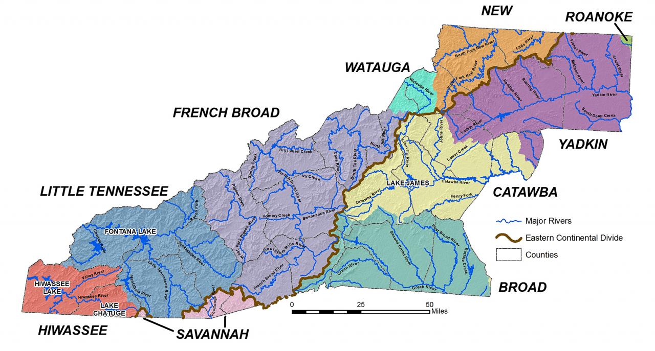
WNC river basins and major tributaries. Non-point source pollution from stormwater runoff is the biggest threat to the health of these rivers. Source: WNC Vitality Index > River Basins.
There are over 7,688 miles of streams in the region including 98 square miles of NCDEQ-designated “Outstanding Resource Waters”, 192 square miles of “High Quality Waters”, and 246 square miles of “Water Supply Watersheds”. Additionally, the backbone of the region, the  French Broad River, is the third oldest river in the world (GroWNC 2013).
The NC DEQ’s Environmental Education River Basins web page provides excellent resources to learn more about WNC river basins through Story Maps and more.
Discover your watershed
 The North Carolina Watershed Stewardship Network is an excellent resource for learning about your watershed and the organizations involved in improving water quality in your area. Just enter your address in their interactive map. After the map zooms to your location, you can zoom out to see your watershed boundary. You can also click on the map, within the boundary, to open a detailed overview of your watershed, and information about: water quality, regulatory actions, land cover, and watershed groups and their activities.
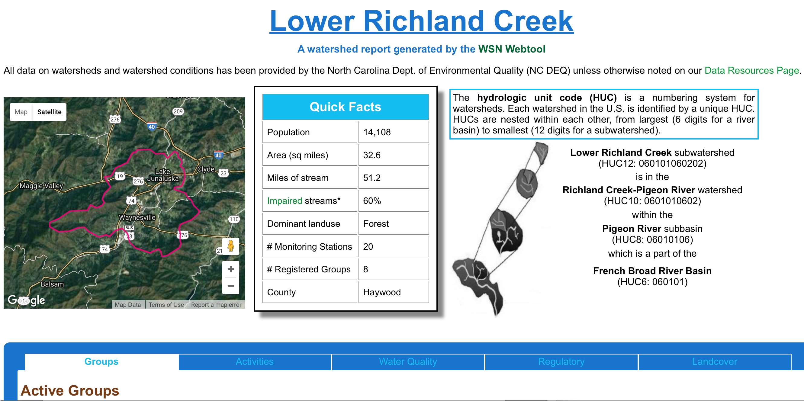
Watershed report generated by clicking on the North Carolina Watershed Stewardship Network interactive map.
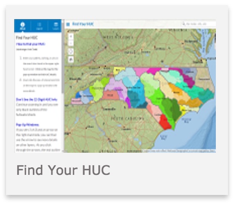
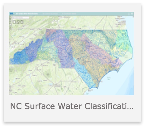
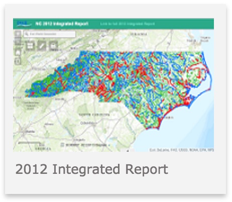
NC DEQ also offers a variety of interactive mapping applications that you can use to find out more about the watershed in which you live, just type in your address:
 |
 |
 |
Find Your HUC identifies your subwatershed, watershed, and subbasin (see the USGS HUC table above). |
NC Surface Water Classifications provides information about the best uses for a particular water resource. Look for the surface waters nearest your home. |
NC 2012 Integrated Report provides a good overview from multiple sources about your watershed and local surface water quality. |
The NC DEQ Basin Planning Branch Maps web page provides additional interactive mapping applications and resources, if you want to take a deep dive into your watershed.
References
USEPA. 2017. Background Information on Watersheds. Available from https://www.epa.gov/hwp/background-information-watersheds
GroWNC. 2013. Regional Plan. Available from www.gro-wnc.org
NRCS. Mississippi River Basin Healthy Watersheds Initiative. Available from https://www.nrcs.usda.gov/wps/portal/nrcs/detailfull/national/programs/initiatives/?cid=stelprdb1048200